Rain continues into our Saturday before cooler air
Meteorologist Jordan Smith has your Friday evening ABC 36 Storm Team forecast
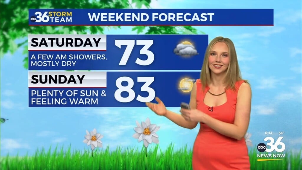
Lexington, Kentucky (WTVQ – ABC 36): Good Friday evening everyone, it has been another gray and damp day across central and eastern Kentucky. Unfortunately, we keep that going into the start of the weekend with more rain and storms on the way for Saturday. The greatest concentration of rain/storms will be during the morning and afternoon. That is when heavy rain is a good bet that could lead to some local high water issues. A strong storm or two can’t be ruled our either in eastern Kentucky where temperatures will hit the 60s. Temperatures elsewhere will be mainly in the 50s.


Rain clears out by Saturday evening as temperatures crash into Sunday morning. Temperatures reach the low 30s by Sunday morning and with leftover moisture, a few snow flurries can’t be ruled out… especially in the southeast.

By Sunday afternoon, temperatures will only be in the low to mid 40s making for a cold March day. But there will be plenty of sunshine so we have that going for us.

Monday – Wednesday looks dry as well with each day adding some degrees onto our temperatures. Monday will see highs in the mid to upper 50s.

Tuesday will see highs in the low to mid 60s.

Wednesday we will see highs in the mid to upper 60s.

Thursday is our warmest day with low 70s, but we will have scattered thunderstorms back into the picture.

As always, stay with the ABC 36 Storm Team for the latest on-air and online. #kywx