Rain and storm chances ramp up Tuesday
Meteorologist Dillon Gaudet has the latest in your full ABC 36 Storm Team forecast
LEXINGTON, Ky. (WTVQ) – Happy Tuesday! We are tracking dry conditions to begin your day but that will change as rain and storm chances return during the midday and afternoon hours. Don’t forget your rain gear today, you’ll need it later in the day. Temperatures will peak in the mid-60s for most. Rain should wrap up by the evening hours for a brief break before more rain moves in late tonight into early Wednesday morning. Rain looks likely to begin the day tomorrow. Rain on Wednesday will be heavy at times, especially early in the day.
Eyes are on a severe weather threat on Thursday. An area of low pressure will be sweeping through the Ohio River valley during the daytime on Thursday. Our severe weather threat will dependent on the exact track and timing of the area of low pressure. The confidence in the exact track is still up in question, meaning there is still uncertainty around our severe threat. As of Tuesday morning, most of the ABC 36 viewing area is in a “Level 2” Severe Risk. Damaging wind gusts, isolated tornadoes, and isolated large hail are all possible within this area.
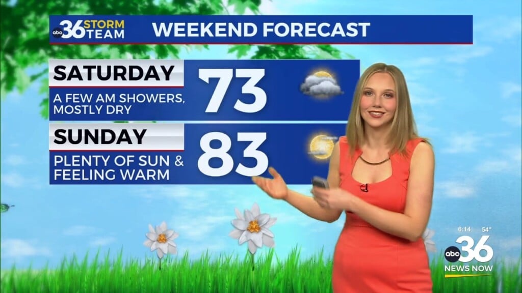
As this system sweeps through the region Thursday night into Friday, a passing cold front will drop our temperatures into the 50s Friday afternoon. There will be isolated lingering showers and maybe a storm or two possible on Friday as well. We will be drying out briefly on Saturday, before rain chances return to close out the weekend.
Stay with the ABC 36 Storm Team for more updates.
ABC 36 HOUR FORECAST
TUESDAY: Scattered showers and thunderstorms. Highs in the mid-60s.
TUESDAY NIGHT: Rain chances increase late. Lows in the 50s.
WEDNESDAY: Showers and thunderstorms likely, heavy at times. Highs in the upper 60s and low 70s.