Our focus now shifts to arctic cold and snow
Meteorologist Jordan Smith has your Friday evening ABC 36 Storm Team forecast
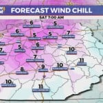
Lexington, Kentucky (WTVQ – ABC 36): Good Friday night everyone, it has been one crazy weather day with rounds of heavy rain and high winds of 50-60mph causing damage and power outages across Kentucky. Now the heavy rains is pushing out of the area, the winds are calming down some (gust still 30mph+ through tomorrow), and we are focusing on arctic air diving in and several snow chances. After hitting the low 50’s this afternoon, temperatures will drop all the way down to the low to mid 20s by Saturday morning with wind chills in the upper single digits to low teens. WOW! A few snow showers and flurries will fill the sky tonight into Saturday morning as well and some hit and run light accumulations can’t be ruled out.


Highs by Saturday afternoon are into the low to mid 30s under a partly sunny sky with a wind chill in the 20s.


An even stronger arctic boundary slides through Kentucky Saturday night into Sunday morning and that looks to touch off some light snow showers and flurries. Those could lay down some hit and run light accumulations as well. 
That will take temperatures WAY down by Sunday morning with upper single digits to low teens for actual temperatures. Wind chills could go below 0.


Sunday afternoon temperatures will only reach the upper teens with wind chills potentially staying in the single digits to low teens all day.


That brings us to our Monday – Tuesday system that will likely bring accumulating snow to “parts” of Kentucky. As of now, southern and eastern Kentucky have the “best” chance at putting snow on the ground with everyone having a chance.

We will fine tune that map and throw snowfall numbers out there this weekend so stay tuned for that. Regardless of the snow, we are going to see another blast of arctic air into midweek that will be even colder than this weekends blast. Actual low temperatures could reach the low single digits to near 0 and wind chills could be WELL below 0.


ANOTHER snow potential then comes Thursday night into Friday as our hyper active pattern continues.

Stay with the ABC 36 Storm Team on-air and online through out it all! #kywx