Heavy rain and strong storms continue through Saturday as flooding threat increases
Stormy Start to Friday
It’s been another wet start across Central Kentucky as showers and thunderstorms pushed through the area during the morning hours. Some of those storms have already produced heavy rainfall, and this is only the beginning of what looks to be another active day of weather.
Additional rounds of showers and thunderstorms are expected to develop later this afternoon and continue through the evening. While there may be occasional breaks in the rain, don’t let those fool you, more storms are expected to redevelop throughout the day.
The atmosphere remains loaded with moisture, and several disturbances moving through the region will keep rain chances elevated well into Saturday.
Flash Flooding Becomes the Main Concern
A Flood Watch remains in effect through Saturday morning for areas along and north of the Interstate 64 corridor as the threat for flash flooding continues to increase.
Several rounds of thunderstorms are expected to move over many of the same locations, creating the potential for training storms. This setup could quickly overwhelm drainage systems and lead to flooded roads, especially in areas that have already picked up significant rainfall over the past several days.
Most locations can expect an additional 1 to 2 inches of rain, but localized totals of 3 to 5 inches are possible where storms repeatedly track over the same area. If you encounter a flooded roadway, remember to turn around, don’t drown.
Strong Storms Possible This Afternoon and Tonight
In addition to the flooding threat, some storms this afternoon and evening could become strong to severe.
The greatest severe weather threat will be across southern Indiana and central Kentucky, where the Storm Prediction Center has placed portions of the area under a Level 2 out of 5 Slight Risk for severe weather.
The primary concern will be damaging wind gusts, but an isolated tornado or two cannot be ruled out. While the tornado threat remains relatively low, it’s not zero, so it’s important to stay weather aware through tonight.
The exact placement of the strongest storms will depend on where the atmosphere is able to recover after this morning’s rain. If sunshine breaks through for a time this afternoon, storms could become stronger rather quickly.
Rain Chances Continue Into Saturday
Unfortunately, the unsettled weather doesn’t end tonight.
Showers and thunderstorms are expected to continue on and off through Saturday as a slow-moving front gradually works south across Kentucky. Storms will likely become more scattered during the day, but any storm that develops will still be capable of producing heavy rainfall because of the abundant moisture already in place.
Flooding concerns may begin shifting farther south across Central Kentucky on Saturday depending on where the heaviest rain falls today.
By Sunday, we’ll finally begin to see the pattern improve. A few isolated showers or storms may linger during the morning and early afternoon, but rain chances will gradually decrease as drier air begins working into the region.
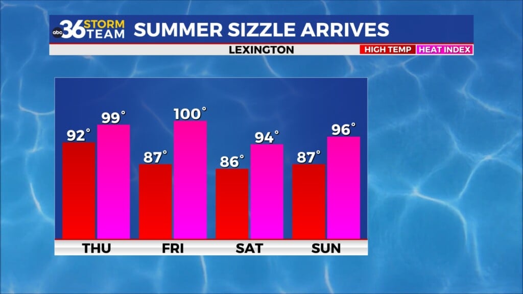
Summer Heat Arrives Next Week
Once we finally dry out, the weather pattern flips dramatically.
Strong high pressure will build across the eastern United States early next week, bringing several days of hot and humid weather to Kentucky.
Afternoon temperatures will climb into the low and middle 90s Monday through much of next week. Combined with dew points remaining in the 70s, heat index values will likely soar well into the triple digits.
Many locations could see heat index values exceeding 100 degrees beginning Monday west of Interstate 65 before expanding across much of Kentucky Tuesday through at least Friday. Some urban areas could even approach 105-degree heat indices, creating an increased risk for heat-related illnesses.
After several days of tracking storms and flooding concerns, next week’s biggest weather story may quickly become dangerous summer heat.
ABC 36 Storm Team 36-Hour Forecast
Friday: Numerous showers and thunderstorms. Some storms could become strong to severe with damaging winds, torrential rainfall, and an isolated tornado possible. Highs in the upper 70s to middle 80s.
Friday Night: Showers and thunderstorms continue. Heavy rainfall and flash flooding remain the primary concerns overnight. Lows in the upper 60s to lower 70s.
Saturday: Scattered showers and thunderstorms continue, especially across central and southern Kentucky. Localized flooding remains possible. Highs in the low to mid 80s.