Chilly mornings and mild afternoons through the week
Possible record-breaking temperatures
Our morning low temperatures have been in he lower 50s with a few even dropping ot the upper 40s. Wednesday morning, we look to cool down further with even more dipping into the 40s. With this, we may break a few record lows. This pattern may continue into Thursday; however, cloud coverage could play a role in keeping temperatures on the milder side if we see those clouds sticking around overnight Wednesday into Thursday.
Pleasant afternoons ahead
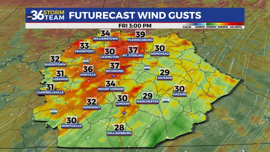
Temperatures in the mid to upper-70s will continue through the end of the work week. We’ll be dry and a bit breezy, leaving us great conditions for heading outdoors to enjoy the fall preview. Just keep in mind that ragweed allergens are on the rise, so allergy medication is a must! Also, use a bit of caution if grilling or having a fire outdoors, as dry air and gusty winds can lead to fires behaving a bit erratically.
A warmer holiday weekend
Temperatures are trending closer to average in the low 80s for the weekend. It is possible that cloud cover could build in and bring us temperatures closer to 80 degrees, and possibly some isolated showers on Sunday. However, most models indicate a dry and warm Labor Day weekend for us. Monday marks the onset of potential unsettled weather, with a 20% chance of isolated showers for now. Most should still be good to go for any outdoor plans!
Tuesday: Mostly sunny and very nice. Highs in the mid-70s. Wind: NW 5-10 mph.
Tuesday Night: Mostly clear, near record lows. Lows in the upper-40s to around 50 degrees. Wind: N 5-10 mph.
Wednesday: