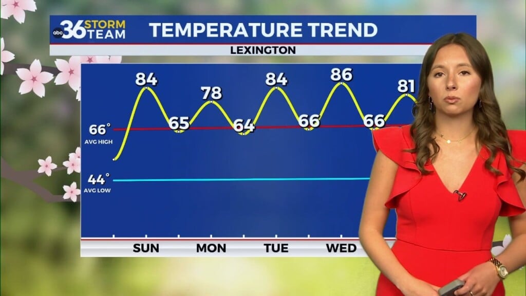
Chilly mornings and cooler afternoons for the rest of the week
Grab a jacket, today will be brisk
Temperatures on our Wednesday morning are in the 40s and upper 30s. Through the afternoon, winds will pick up and will be gusty out of the west. High temperatures today will only reach the upper 50s for most. With those temperatures staying a few degrees below average and winds gusting up to 25-30 mph, we’ll feel quite cool throughout the day. A jacket, sweatshirt, flannel, or any other kind of fall attire will be needed throughout the day. This is especially true if heading outdoors, like to Keeneland.
Frost is looking likely tomorrow morning
A frost advisory will take effect on Thursday at 4:00 a.m. and will last until 9:00 a.m. for most counties in the Bluegrass. This is due to temperatures likely falling into the 30s. Those to the SW will see overnight clouds, and that will keep them in the 40s. But others, especially to the north, will drop near freezing. This will cause our first widespread frost of the season, putting sensitive plants at risk. If you have any outdoor plants, move them indoors tonight or water them this morning, then cover with a sheet tonight.
Dry through the end of the week
The same weather will persist through Saturday, with chilly mornings and mild, breezy afternoons, and lots of sunshine. We may see more widespread frost on Friday morning, but Saturday morning will be a bit milder. Saturday looks to be dry and fall-like for the UK game, with any rain chances holding off until Sunday and into the next work week.