Active weather on the horizon, several changes ahead
Thursday – Friday
Thursday will be a calm and seasonal day. Temperatures will be near average, in the high 50s to low 60s. Lots of sunshine during the day with a light eastern breeze. Overnight, winds will pick up out of the south, gusting up to 25 mph. Clouds will build late, and by Friday morning, we’ll be mostly cloudy. We may see a few isolated rain showers through the late morning and winds will be gusty, with temperatures in the mid 60s. The main event comes on Friday afternoon as a line of showers and storms moves through along a cold front.
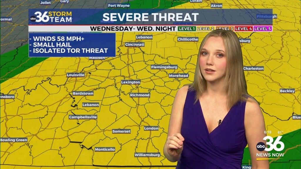
This event is conditional, in that if we are able to gather enough instability during the day, we may see some storms becoming strong to severe. However, confidence is low that we will see temperatures warming up enough during the day due to cloud cover. If storms do strengthen, the best chance for seeing stronger activity will be to the southwest, where a level 2 severe risk is present. Those to the east will see storms weakening as they move through. Main hazards if we see any stronger storms would be winds gusting 58+ mph, small hail, and a very low tornado threat. Be sure to stay weather aware and have ways to get alerts, but don’t expect to see widespread severe storms.
Saturday – Sunday
Storms will move out of the area overnight Friday, leaving us dry but cloudy for Saturday. High temperatures on Saturday will be in the mid-60s. UK plays Florida at 7, meaning the sun will be setting during tailgating. This means we may get a bit chilly, so be sure to bring extra layers to the game or any other outdoor plans. Late Saturday, close to midnight, another cold front will move through. This front will see a few isolated showers into Sunday morning, but the biggest impact will be the temperature difference. Behind the front, temperatures will drop to the upper 40s for Sunday afternoon. Some rain showers may wrap around the back end of the system heading into Sunday night and Monday morning.
Monday – Extended Forecast
With temperatures overnight Sunday cooling down to the 20s, it’s possible that some of the isolated rain showers become mixed with some snow. This would be very light, with little to no accumulation possible. Grounds are still too warm for snow to stick. During the day on Monday, high temperatures are trending cold in the 40s and 30s. You’ll want to have the coat, gloves, and hats ready to go. We’ll be cloudy during the day, and a few flurries may get squeezed out. These will have no impact on travel.
Temperatures will steadily return to average through the week, so these wintry conditions don’t stick around for long. Tuesday morning will likely be the coldest in the low 20s, but Tuesday afternoon will be back into the upper 40s. Wednesday is trending in the 50s.