A very warm week leads to rain and storms
Meteorologist Jordan Smith has a look at your Sunday evening forecast!
Lexington, Kentucky (WTVQ – ABC 36): Good Sunday evening everyone, after a cold and frosty start we warmed up into the low 60s by this afternoon under full sunshine. Here is what I am tracking in the days to come for tonight’s weather headlines.

Monday is mainly dry with high temperatures into the low 70s, but I can’t completely rule out a stray shower or storm. If you see a shower or storm, it could knock temperatures down into the 60s briefly.

Tuesday is a day straight out of early June rather than April with a partly sunny sky and high temperatures in the low to mid 80s. Once again, I can’t completely rule out a stray shower or storm but most should stay dry.

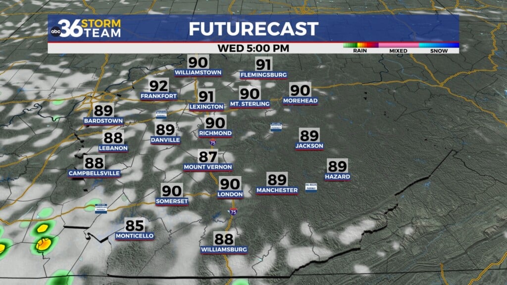
Once past those days, it’s time to focus on a strong to severe storm threat on the way for Wednesday. Some rain and thunder may move in earlier in the day with the strong storm threat late afternoon through the evening. Backside rain will then follow the storms up into Thursday morning as the cold front passes through.

You can see the line of storms into the afternoon and evening very well on the extended future cast.

That knocks high temperatures down into the upper 50s to near 60 for Thursday and Friday afternoon, but skies will be dry. I know a lot of you has plans for Easter weekend and the early forecast call for that is temperatures into the mid to upper 60s with some rain around. Exactly how much rain and widespread it is will have to be determined in the days to come as we see exactly where the area of low pressure tracks. You want it to go way south so we stay more dry than wet.
As always, the ABC 36 Storm Team will keep you up to date and safe ahead of it all on-air and on-line! #kywx
ABC 36 HOUR FORECAST
SUNAY NIGHT: Increasing clouds and not as cold. Lows in the low-40s.
MONDAY: A very pleasant day with only a slight shower or storm chance. Highs in the low-70s.
MONDAY NIGHT: Some clouds around and maybe a sprinkle. Lows in the low-50s.