Sunshine and comfortable air stick around before storms return late this week
A beautiful midweek stretch gives way to increasing rain chances, heavy rainfall potential, and rising summer heat next week.
Sunshine and Lower Humidity Make for a Beautiful Wednesday
We started off today with lots of sunshine and temperatures into the 60s across the area, and also some patchy fog as well. We will continue to see lots of sunshine today as a area of high pressure remains firmly in control of our weather pattern, delivering comfortable temperatures and noticeably lower humidity levels.
Afternoon highs today will climb into the lower 80s across Central Kentucky, making for another excellent day to spend time outdoors. While temperatures are seasonable for late June, the biggest difference compared to recent weeks is the much drier air. Dew points have fallen significantly, creating a much more comfortable feel across the region.
Quiet and Comfortable Tonight
The pleasant weather continues tonight with mostly clear skies and light winds. Overnight temperatures will fall into the lower 60s across much of the area.
Some sheltered valleys and low-lying locations could briefly dip into the mid-50s by early Thursday morning. A few pockets of patchy fog cannot be ruled out before sunrise, but widespread visibility issues are not expected.
Warmth and Humidity Begin Returning Thursday
Thursday will start dry with a mix of sunshine and a few clouds. As high pressure shifts east, winds will begin turning out of the southwest, allowing warmer and more humid air to gradually return to Kentucky.
Afternoon temperatures will rise into the middle 80s, with humidity levels steadily increasing throughout the day. Most areas will remain dry through much of Thursday, but by late afternoon and especially Thursday night, shower and thunderstorm chances will begin increasing.
Some storms that develop Thursday afternoon and evening could become locally strong, with gusty winds and heavy rainfall being the primary concerns.
Wet Pattern Develops Through the Weekend
The overall weather pattern turns more active beginning Thursday night and continuing through Saturday night as a stalled frontal boundary sets up near Kentucky.
Multiple rounds of showers and thunderstorms are expected to develop along this boundary. The biggest concern will be heavy rainfall, especially across southern Indiana and northern Kentucky where storms may repeatedly move over the same locations.
Forecast guidance continues to indicate the potential for widespread rainfall totals of 3 to 4 inches through the weekend, with locally higher amounts possible where storms repeatedly track over the same area. If current forecast trends continue, flood watches may eventually be needed for portions of the region.
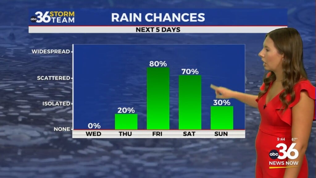
Friday and Saturday currently appear to be the most active days for widespread showers and thunderstorms. While severe weather potential remains somewhat uncertain, the threat for localized flooding continues to increase.
A Drier Pattern Returns by Early Next Week
By Sunday, the stalled boundary should begin lifting northward, allowing rain chances to gradually decrease. While a few showers and storms may still be possible, the overall trend will be toward drier conditions heading into early next week.
As high pressure and upper-level ridging strengthen across the eastern United States, temperatures will begin climbing once again.
Summer Heat and Humidity Build Next Week
The biggest weather story next week may become the return of summer heat and humidity.
Temperatures are expected to climb into the low to mid-90s by Tuesday and Wednesday, especially across southern Kentucky. Combined with increasing humidity, heat index values could approach or exceed 100 degrees in some locations.
Unlike the dry and comfortable air we’re currently enjoying, next week’s weather will feel much more typical for late June and early July. Warm overnight temperatures and elevated humidity levels could create several days of uncomfortable conditions across the Bluegrass State.
ABC 36 Storm Team 36-Hour Forecast
Wednesday: Mostly sunny and less humid. Highs in the low 80s.
Wednesday Night: Mostly clear and comfortable. Lows in the upper 50s to lower 60s.
Thursday: Partly sunny, warmer and more humid. Highs in the mid-80s with increasing chances for showers and thunderstorms late in the day.