Sunshine and comfortable conditions return before storm chances increase later this week
Kentucky enjoys a refreshing break from the humidity as dry weather settles in through Wednesday.
Lingering Clouds and Showers Exit as Sunshine Takes Over
After several days of active weather and heavy rainfall across Kentucky, conditions are finally beginning to quiet down. While portions of southern Kentucky started the day with lingering cloud cover and a few leftover showers, much of the northern half of the viewing area has already been enjoying plenty of sunshine.
Those remaining clouds and showers across southern and southeastern Kentucky will continue to move out through the afternoon, allowing sunshine to spread across the entire region. High pressure building into the Ohio Valley is helping bring drier air into the area, setting the stage for a much more comfortable day.
Cooler Temperatures and Much Lower Humidity
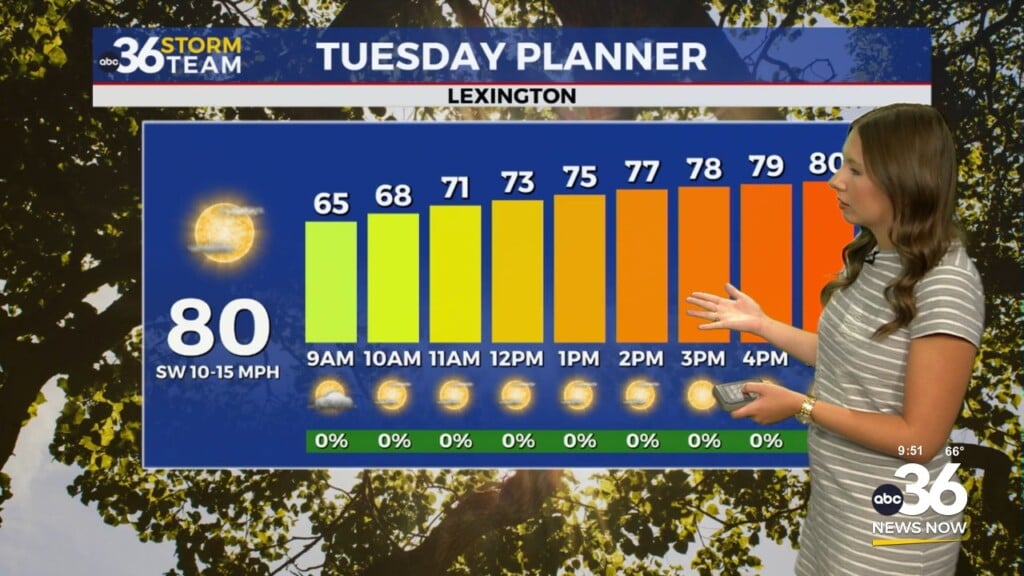
As we move through the afternoon, temperatures will climb into the upper 70s and lower 80s across much of Central and Eastern Kentucky. While temperatures are only slightly cooler than what we’ve seen recently, the biggest difference will be the humidity.
Behind Monday’s cold front, significantly drier air has filtered into the region. Dew points have fallen into the 50s and lower 60s, making it feel noticeably more comfortable compared to the muggy conditions that dominated much of the past week.
Combined with abundant sunshine and light northerly winds, today will be one of the nicest days we’ve seen in quite some time.
Quiet Weather Continues Tonight and Wednesday
The pleasant weather pattern will continue tonight as skies remain mostly clear across the region. Overnight temperatures will fall into the upper 50s and lower 60s, with some sheltered valleys potentially dropping into the lower 50s by daybreak Wednesday.
Wednesday is shaping up to be another fantastic summer day. High pressure will remain in control, bringing mostly sunny to partly cloudy skies and afternoon temperatures in the lower 80s. Light winds and continued low humidity will make for excellent conditions if you have outdoor plans.
Some patchy fog could develop in the usual low-lying locations Wednesday morning, but widespread visibility issues are not expected.
Rain Chances Return Late This Week
The dry stretch will continue through most of Thursday before our next weather system approaches the Ohio Valley.
As winds shift back out of the southwest, temperatures will climb into the mid to upper 80s while humidity levels steadily increase. Moisture returning to the area will set the stage for scattered showers and thunderstorms beginning late Thursday and continuing into Friday and Saturday.
The highest rain chances currently appear to be Thursday night through Friday, when a slow-moving disturbance and cold front move through the region. Forecast guidance suggests some areas, especially north of a line from Hardinsburg to Lexington, could receive more than two inches of rainfall by early Saturday.
While exact rainfall amounts and locations remain uncertain, additional beneficial rainfall appears likely after the recent dry conditions across parts of Kentucky.
Storm Chances Continue Into the Weekend
Shower and thunderstorm chances will linger through at least part of the weekend as a series of disturbances move through the Ohio Valley. It will not be a washout, but periods of rain and thunderstorms are expected, particularly Friday and Saturday.
Any storms that develop could produce heavy downpours due to the increasing moisture in the atmosphere. Forecast confidence is growing that multiple rounds of rain will impact the region before conditions begin improving later in the weekend.
Summer Heat Returns Next Week
Looking ahead, the overall weather pattern will begin shifting toward a much hotter and more humid setup by early next week.
High pressure building across the eastern United States will allow temperatures to climb into the upper 80s and lower 90s by Monday and Tuesday. Humidity levels will increase significantly as well, potentially pushing heat index values above 100 degrees in some locations.
While that forecast is still several days away, it appears Kentucky may get its first extended taste of true summer heat as we close out June.
ABC 36 Storm Team 36-Hour Forecast
Tuesday: Mostly sunny and much less humid. Highs in the upper 70s to low 80s.
Tuesday Night: Mostly clear and comfortable. Lows in the upper 50s to low 60s.
Wednesday: Sunny to partly cloudy with pleasant conditions continuing. Highs in the low 80s.