Flooding concerns linger Monday before sunshine returns to Kentucky
Additional showers remain possible this afternoon before a stretch of dry weather arrives through midweek.
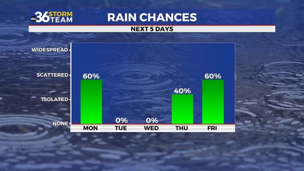
Heavy Rain and Flooding Concerns to Start Monday
It was a stormy and soggy start to the week across Central Kentucky as multiple rounds of showers and thunderstorms moved through the area overnight and into Monday morning. Many communities picked up significant rainfall, and several flooded roadways were reported across the Lexington metro area as storms repeatedly moved over the same locations.
The heaviest rain fell where storms trained across portions of the region, producing localized flooding concerns. Some areas across Kentucky have already received several inches of rain over the past 24 hours, with additional rainfall expected before conditions finally improve later today.
Showers Continue This Afternoon, Especially Across Southern and Eastern Kentucky
While much of the area has begun drying out this morning, the forecast remains unsettled for portions of southern and eastern Kentucky this afternoon.
A slow-moving cold front continues to push southeast through the Commonwealth, and enough moisture remains in place for additional scattered showers and thunderstorms to develop through the afternoon and early evening hours. The atmosphere is not particularly favorable for widespread severe weather, but any storms that do develop will still be capable of producing gusty winds, frequent lightning, and very heavy rainfall.
The greatest concern continues to be flooding, especially in locations that have already received heavy rain over the past day.
Flood Watch Remains in Effect Through Tonight
A Flood Watch remains in effect through 11 PM this evening for portions of southern and eastern Kentucky where the risk for additional heavy rainfall remains highest.
The atmosphere remains very moisture-rich, and any thunderstorms that repeatedly move over the same area could quickly lead to flash flooding issues. Rainfall totals through the remainder of today could range from a quarter inch to three-quarters of an inch for many locations, with isolated areas receiving 1 to 3 inches where storms train.
Residents should continue to monitor weather conditions closely and avoid driving through flooded roadways.
Sunshine Returns for Tuesday and Wednesday
The good news is that the unsettled weather pattern finally begins to move out of the area tonight.
As the cold front pushes southeast and drier air filters into Kentucky, showers and storms will gradually come to an end by early Tuesday morning. Cloud cover will decrease overnight, and a few areas could even see some patchy fog develop before sunrise.
Tuesday is shaping up to be a beautiful summer day with mostly sunny skies, lower humidity, and temperatures climbing into the low 80s. Dry conditions are expected to continue through Wednesday as high pressure settles over the Ohio Valley.
Temperatures will gradually warm through the middle of the week, with highs climbing from the lower 80s Tuesday into the mid and upper 80s by Thursday.
More Rain Chances Return Later This Week
The break from the rain will be relatively short-lived as another weather system approaches the region later this week.
Rain chances begin increasing Thursday evening and continue through Friday and Saturday as several disturbances move through the Ohio Valley. Current forecast trends suggest the most widespread rainfall could arrive Thursday night into Friday morning, with additional rounds of showers possible through Saturday.
The heaviest rainfall appears most likely along and north of the Ohio River, but showers and thunderstorms will be possible across much of Kentucky.
Warmer Weather Returns by Sunday
By the end of the weekend, upper-level high pressure is expected to build back into the region, allowing warmer and drier conditions to return.
Temperatures will climb back into the upper 80s and potentially near 90 degrees by Sunday and early next week as summer heat begins to make a comeback across the Bluegrass State.
ABC 36 Storm Team 36-Hour Forecast
Monday: Scattered showers and thunderstorms, especially across southern and eastern Kentucky. Heavy rain and localized flooding remain possible. Highs in the upper 70s to low 80s.
Monday Night: Showers gradually come to an end with decreasing clouds overnight. Patchy fog possible by early Tuesday morning. Lows in the low 60s.
Tuesday: Mostly sunny, less humid, and dry. Highs in the low 80s.