Cooler air sticks around briefly before summer like heat returns this weekend
Kentucky stays cool and dry through Friday before temperatures surge into the upper 80s and low 90s this weekend
A Chilly Start Across Central And Eastern Kentucky
It was another cool start to the day across Central and Eastern Kentucky as temperatures dropped back into the low 40s overnight, with a few locations even dipping into the upper 30s early Thursday morning.
Despite the chilly start, sunshine quickly returned across the region today with mostly sunny skies for many communities. Some passing clouds have mixed in at times this afternoon, but overall conditions have remained dry and pleasant.
Cooler northerly winds behind a recent cold front have helped keep temperatures below average for mid-May. Afternoon highs today are only expected to climb into the mid 60s and low 70s across much of the viewing area.
Winds have also been a bit breezy at times today, with gusts reaching around 15 to 20 mph through the afternoon.
Another Cool Night Ahead Tonight
As we head into tonight, skies will remain mostly clear with light winds developing as high pressure settles directly over Kentucky.
That setup will allow temperatures to cool off quickly once again overnight, with lows dropping back into the low to mid 40s across the area.
While widespread frost is not expected tonight, some of the colder valleys and sheltered areas could still feel quite chilly by early Friday morning.
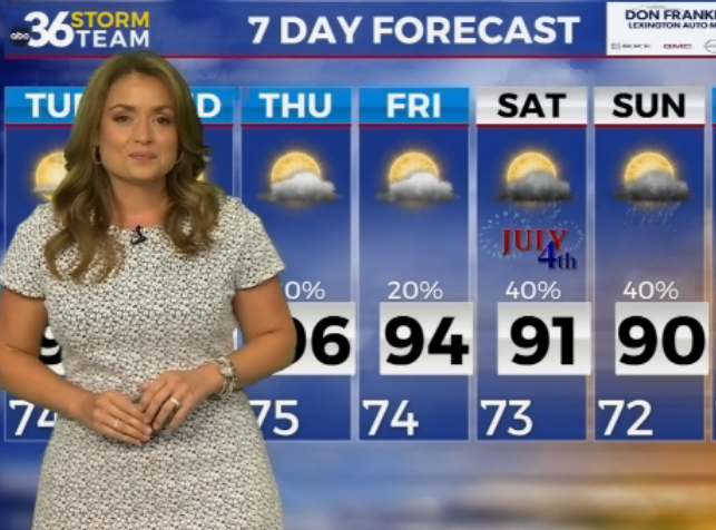
Friday Brings A Warm-Up And A Small Shower Chance
Friday is looking like another really nice day across Kentucky as temperatures begin warming back up.
Southerly winds will return by Friday afternoon, helping boost highs back into the 70s, with some locations potentially reaching the low 80s by the end of the day.
Most of the area is expected to stay dry, but an isolated shower or two cannot be ruled out as a weakening disturbance moves through the Ohio Valley. The best chance for a brief shower looks to remain along and north of Interstate 64 and possibly parts of southern Kentucky later in the day. Dry air near the surface though should limit rainfall totals considerably.
Any isolated showers that do develop should quickly fade by Friday evening, leaving behind another quiet and mild night.
Summer-Like Heat Builds Into The Weekend
A major warm-up is expected this weekend as a much warmer air mass moves into the Ohio Valley.
Saturday temperatures are forecast to climb well into the 80s, with some areas potentially reaching the upper 80s by the afternoon. Increased humidity will also return, making it feel much more like summer across the region.
At the same time, scattered showers and thunderstorms are expected to develop during parts of the day Saturday as waves of moisture move into Kentucky. While widespread severe weather is not expected right now, a few storms could still produce heavy downpours, lightning, and gusty winds.
If you have outdoor plans this weekend, whether heading to the pool, grilling out, or attending outdoor events, make sure to keep an eye on the radar, especially Saturday afternoon and evening when a few rumbles of thunder could develop.
Near Record Heat Possible Sunday And Early Next Week
Sunday is looking much hotter and drier across Central and Eastern Kentucky.
Forecast highs are expected to soar into the upper 80s and even low 90s in some locations as sunshine returns and warm southwest flow continues across the region.
That summer-like heat is expected to continue into early next week, with highs remaining well above average through Monday.
Rain and thunderstorm chances will begin increasing again by Monday night into Tuesday as another system approaches from the west. Forecast models show increasing moisture ahead of the next cold front, which could bring additional rounds of showers and thunderstorms to the Ohio Valley.
ABC 36 Storm Team 36 Hour Forecast
Wednesday Night
Mostly clear and chilly with overnight lows dropping into the low to mid 40s.
Thursday
Mostly sunny with a few passing clouds. Cooler temperatures continue with highs in the mid 60s to low 70s.
Thursday Night
Clear to partly cloudy skies with another cool night expected. Overnight lows fall back into the mid 40s.