A soggy start leads to a drier and sunnier afternoon
Light rain fades early before skies clear out
Clouds hang tough early on, with scattered light rain moving across parts of central and southern Kentucky. Most of the rain stays fairly light, and many areas pick up little more than a few hundredths of an inch. The best chance for steadier showers looks to be south of the Western and Bluegrass Parkways, especially closer to the Lake Cumberland region.
The rain gradually tapers off through the morning, and skies begin clearing from west to east. By the afternoon, sunshine takes over for most areas, helping temperatures recover into the low 70s.
A few fair-weather clouds may pop up during the afternoon, but overall it turns into a pleasant spring day after the gray start.
Cool nights and a beautiful Tuesday
Clear skies and light winds Monday night allow temperatures to drop back into the 40s by early Tuesday morning, making for a cool and refreshing start to the day.
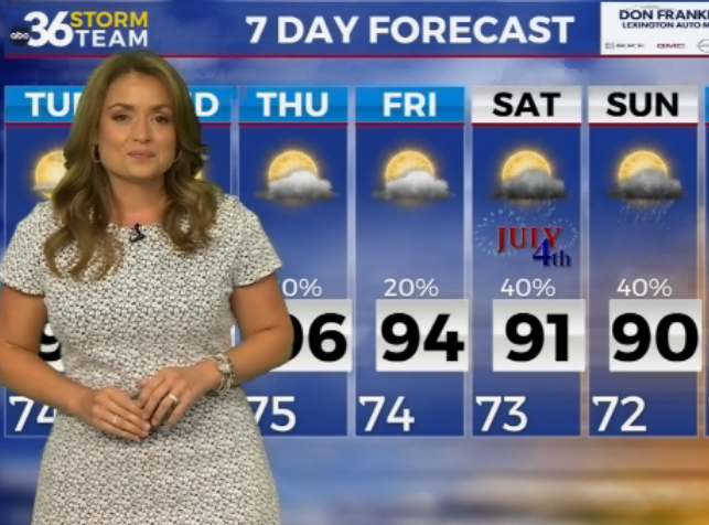
Tuesday looks like one of the nicest days of the week. Sunshine dominates from start to finish, and temperatures warm quickly into the mid and upper 70s by afternoon. A light southwest breeze develops later in the day, helping bring in milder air ahead of the next system.
Midweek cold front brings scattered showers
Rain chances return late Tuesday night into Wednesday as a cold front sweeps through the Ohio Valley. Showers move into southern Indiana before daybreak and gradually spread southeast through Kentucky during the day.
Rainfall amounts look fairly light overall, but a few showers could linger into Wednesday afternoon, especially across eastern Kentucky and near the Bluegrass region. There is also a small chance for a few thunderstorms to develop if the front slows down enough during the afternoon.
Wednesday stays breezy, with wind gusts reaching 20 to 25 mph at times as winds shift from southwest to northwest behind the front. Temperatures still manage to climb into the upper 70s before cooler air settles in later in the day.
Dry weather returns before a big warmup this weekend
High pressure builds back into the region Thursday, bringing sunny skies and dry weather once again. Afternoon temperatures settle into the upper 60s and low 70s, offering another comfortable spring day.
A few isolated showers could return Friday into the weekend, but rain chances remain fairly low and many areas may stay dry most of the time.
The bigger story heading into the weekend will be the warming trend. Temperatures climb well into the 80s by Saturday, and some spots could flirt with 90 degrees by Sunday as a much warmer air mass moves into Kentucky.