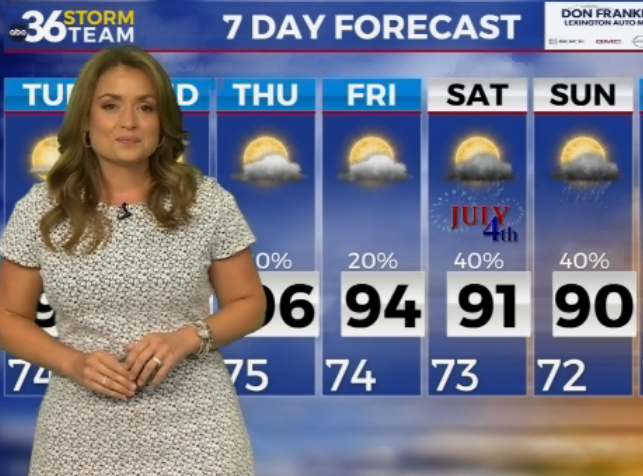
Strong storms possible tonight before cooler pattern settles in
Storms Exit, Brief Break Follows
By mid-morning, the earlier line of storms has largely weakened and pushed out of central and eastern Kentucky. A few lingering showers may still be around, but the overall trend is quieter conditions with clouds gradually thinning.
With some breaks developing, temperatures rebound into the upper 70s and low 80s. Humidity remains noticeable, setting the stage for the next round of weather later on.
Strong Storms Return This Evening
Another round of storms is expected to develop and move into the region during the evening and overnight hours.
This system has a better setup to produce strong to severe storms, especially across southern Kentucky, but central and eastern areas are still included in the risk. Damaging winds and large hail are the primary concerns as storms move through, but a spin-up tornado cannot be ruled out.
Have multiple ways to receive weather alerts overnight.
Storms are expected to gradually weaken later in the night, though showers may linger into early Wednesday. Expect on and off drizzle throughout Wednesday afternoon
Turning Cooler Midweek
As the system exits, a cold front pushes through, bringing a noticeable change. Any lingering rain tapers off, and cooler, drier air begins to move in.
Afternoon temperatures settle back into the 60s and low 70s, with a much more comfortable feel compared to the recent warmth.
The cooler trend continues through the end of the week and into the weekend. Highs generally remain in the 60s, with nighttime lows dropping into the 40s and even upper 30s in some areas.
Mainly Dry With Minor Rain Chances
After the midweek system moves out, most of the period looks dry. A weak disturbance could bring a slight chance for light rain heading into Friday evening and Saturday, but widespread impacts are not expected.