Spring-like temperatures and rain expected to continue
Rain and storms continue today
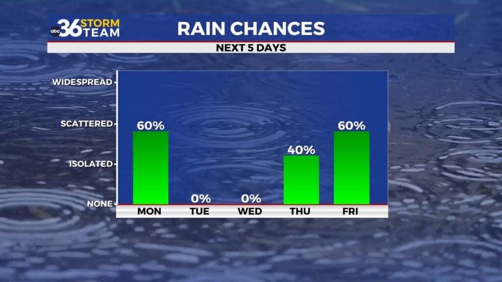
Periods of rain and a few thunderstorms will continue across the Bluegrass region as a strong weather disturbance moves through the Ohio Valley. A surge of moisture from the Gulf of Mexico is helping fuel the showers, allowing rainfall to become steady at times through the late morning hours.
The most widespread rain is expected during the morning and midday period, with scattered thunderstorms also possible. Some storms could produce brief, heavier downpours, especially across the northern parts of central Kentucky. A few storms may also have gusty winds and brief, small hail. A Level 1 Severe Risk still exists through the late morning hours.
Rain coverage may gradually decrease later in the day as the main system moves east, though scattered showers could linger into the evening.
Rainfall totals across the Bluegrass will generally be lighter than in areas farther north, but some locations could still pick up locally higher amounts where storms pass repeatedly. Ponding of water on roads may occur in spots during heavier rain.
Showers linger tonight
Even after the main system moves away, plenty of moisture will remain in place across the region. This could allow additional scattered showers or a few rumbles of thunder to redevelop overnight.
Temperatures will remain unusually mild for early March, staying well above normal both during the day and overnight. Thursday afternoon will be near 70, and overnight will only cool to the upper 50s.
Near-record warmth to end the week
The unsettled weather briefly relaxes heading into Friday. While a few isolated showers and storms cannot be ruled out, many areas will see dry periods along with a mix of clouds and sunshine.
Temperatures will surge well above normal, with highs approaching the upper 70s and potentially reaching around 80 degrees in some parts of central and eastern Kentucky.
That warmth could challenge record highs for early March. The record in Lexington is 77 degrees.
Storm chances return this weekend
Another organized storm system is expected to approach the region Saturday, bringing a renewed chance for showers and thunderstorms.
Some of the storms could become strong depending on how much instability develops ahead of an approaching cold front. Most of the Bluegrass is under a Level 1 Severe Risk, with northeastern KY falling under a Level 2 Risk. The main threat as of now looks to be damaging wind gusts.
Rain and storms are most likely later Saturday into Saturday evening as the front moves through the region.
Unsettled pattern continues next week
After the weekend system passes, the front is expected to stall just south of Kentucky, keeping the weather pattern somewhat unsettled. While there may be dry periods, additional disturbances could bring periodic chances for rain into early next week.
Temperatures are expected to remain well above normal through much of the period, continuing the springlike trend across the Bluegrass. Over several days, rainfall totals could add up to several inches across parts of the region, which may help ease drought conditions in portions of the Ohio Valley.