Quiet weekend, changes on the way next week
Dry skies stick around this weekend before a cold front brings showers and cooler air next week.
Sunshine Stays Strong
The first weekend of October has been nothing short of summer-like, with dry skies and plenty of sunshine across the region. Highs this afternoon once again climbed into the low to mid-80s, keeping us well above average for this time of year. Tonight, mostly clear skies will help temperatures dip back into the mid-50s, with some patchy fog possible in river valleys by Sunday morning.
Another Warm Day on Sunday
Sunday keeps the pattern going with more sunshine and warmth. Southerly winds will start to develop, adding just a touch of humidity, but the day will still feel very pleasant overall. Highs will reach the mid-80s once again, making it another great day for outdoor plans. A few clouds may arrive late in the day, especially across southern Kentucky, but dry conditions will hold through the weekend.
Early Week Rain Chances
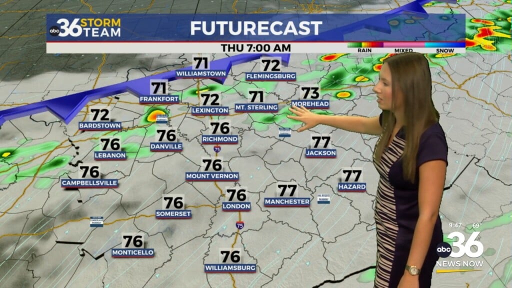
Changes begin Monday as Gulf moisture pushes into the Ohio Valley. This will bring back some scattered shower chances, mainly late in the day and into Monday night. The better chance for widespread rain arrives Tuesday as a cold front approaches, bringing scattered showers and a few thunderstorms. Rainfall totals may range from half an inch to around an inch for most spots — just enough to briefly slow down drought conditions, though not enough for a full recovery.
Midweek Cool Down
By Wednesday morning, the cold front should be through the area, with drier and cooler air moving in from the northwest. Afternoon highs will drop into the low to mid-70s, about 10 degrees cooler than earlier in the week. By late week, mornings will feel especially crisp, with lows dipping into the 40s and 50s. Thursday and Friday look dry with seasonable October temperatures, giving us a much more fall-like feel.
Looking Toward Next Weekend
Confidence drops a bit heading into Friday and Saturday, as some models suggest another disturbance may swing through the region. For now, the forecast leans dry, with temperatures holding near seasonal levels — but it’s something we’ll keep an eye on.
ABC 36 Storm Team 36-Hour Forecast
Saturday Night: Mostly clear and cool, lows in the mid-50s with patchy fog possible.
Sunday: Sunny and warm, highs in the mid-80s.
Sunday Night: Increasing clouds, lows in the upper 50s to low 60s.