Cooler temperature pattern settling in to end the week
Afternoon highs will struggle to reach the low-to-mid 60s on Thursday
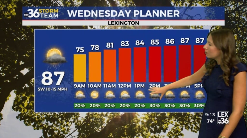
LEXINGTON, Ky. (ABC 36 NEWS NOW) – The cooler pattern we talked about earlier in the week has officially arrived across central and eastern Kentucky. After a damp and breezy Wednesday, today’s temperatures will feel more like early April than late May.
Afternoon highs on your Thursday will struggle to reach the low to mid-60s around the Lexington area, with a mix of clouds, some sunshine, and the chance for a few passing showers. A rumble of thunder can’t be ruled out either—but this certainly won’t be a washout. Winds will remain breezy at times, out of the west-northwest around 10–20 mph, with occasional gusts over 25 mph.
Cold Start Friday Morning
Skies will gradually clear tonight, allowing temperatures to tumble. Expect Friday morning lows in the low-to-mid 40s for most, but some of the sheltered valleys in eastern Kentucky may wake up to readings dipping into the upper 30s. It’ll be the coldest morning we’ve seen in a while—yes, even chillier than Thursday morning.
Despite sunshine through much of the day, Friday will remain on the cool side with highs again stuck in the mid 60s. Winds should be lighter, making for a crisp but calm end to the workweek.
Memorial Day Weekend Outlook
The first half of the holiday weekend looks mainly dry. Friday night and much of Saturday should remain quiet, though a stray shower may sneak into southern Kentucky late Saturday. Highs Saturday should manage the mid to upper 60s across the region, still running 10–15° below normal.
By Sunday, moisture begins to increase ahead of our next system. Scattered showers will become more widespread through the day, especially in the afternoon and evening. A few thunderstorms are also possible, but we are not expecting any severe weather at this time.
Looking Ahead to Memorial Day Monday
If you’re making outdoor plans for Memorial Day, keep an eye on the forecast. Monday appears to be the most active day of the weekend, with showers and thunderstorms likely as a low-pressure system tracks nearby. Rainfall totals of 1–2 inches are possible by the end of the day Monday, with locally higher amounts. The best chance for heavier rain looks to be west and south of Lexington, but much of central and eastern Kentucky will see some wet weather.
As of now, there’s no need for a Weather IMPACT Day—but we’ll keep a close watch in case forecast confidence increases on more widespread or impactful weather.
Cool Pattern Holds Through May
If you’re waiting on a true summer warm-up, you’ll need a little more patience. The overall pattern remains cool through the end of the month. Afternoon highs should hover in the 60s and 70s for most of next week, with continued chances for occasional showers as the upper-level low pressure system lingers nearby.